Last year I hiked the Translagorai route while accompanying my nephew and his friend on their first hiking and wild camping experience. To go full circle, I soloed the Alta Via del Granito last weekend, which covers the parts of the Lagorai mountain range not included in the Translagorai. The AVG is supposed to be a three days effort, with overnights to be spent in managed huts (“Rifugio”), but I wanted to make it in two days while camping in the wilderness. On Day One, I experimented with recording some moments on my GoPro.
Day one
I left at five in the morning and arrived at Malga Sorgazza a few minutes ahead of eight-thirty as planned. The biker-to-hiker transition was pretty quick, and I finally took the trail at about nine.
The first section of the trail, from Malga Sorgazza to Costa Brunella Lake, is a continuous and strenuous climb, initially in the woods. Fortunately, today was a relatively chilly day after weeks of scorching climate. On the bike this morning, I had to wear my rain jacket for chill protection, and I arrived at my destination with numb hands. It took quite some time to warm them up.
Being finally on the trail and climbing up in the woods was invigorating. I resisted the enthusiasm-induced temptation of accelerating and proceeded slowly instead. It paid off, I think, as I was still feeling fresh and strong one hour later as I left the forest behind and started trampling the alpine meadows.
The last stretch before the lake was a tricky incline over beautiful meadows, with open views of Sorgazza Valley and its ranges. I’ve never been here before, but I knew what to expect, as Cima d’Asta and the Alta Via are part of the Loagorai Range I traversed last year while on the Translagorai. Brutal climbs alternated with rapid descents; dark volcanic rocks covered with liches of all kinds and colors, and lush green, high-altitude meadows.
A dam encloses Costa Brunella Lake. At some point, the trail takes you directly to the foot of the dam, and it follows it for the entire length of its wall. The lake is not much, partly because it’s half empty given the drought this season. The trail continued, climbing steadily and still a long way up to Forcella Quarazza, where I arrived in good shape even though fatigue was starting to set in.
Forcella Quarazza welcomed me with a spectacular view. The panorama opens to the south, where you can oversee the Pre-Alps. Today was a beautifully clear day because of yesterday’s thunderstorms, though a bit windy.
The section from Forcella Quarazza to Forzellon de Rava is on technical terrain, always uphill, in its last part especially. Almost at the Forzellon, I wasn’t paying enough attention and didn’t notice a signal denoting a detour. Instead, I followed animal tracks that led me to the ridge in a few minutes. Fortunately, I immediately realized something wasn’t right and looked back, only to see my destination maybe fifty or sixty meters behind me, but I now had to go around a small steep peak. A few minutes later, I was at the Forzellon, back on track.
The next trail section connects the Forzellon with Forcella Ravetta at a slightly lower elevation. It is a long, technical traverse under the Caldenave peak. Here the view opens into this initially stony and wild valley which, further down, reveals the Lago Grande standing right in front of the hiker, on the other side of the valley, with a few alpine pastures and cabins nearby. Toward Forcella Ravetta, two more lakes appear, again on the opposite side, Lago di Mezzo and Lago Primo, below Monte Castelletto and Cima del Frate. I came across a viper sunbathing on the trail stones. She didn’t hear me; I was coming from above, behind, and under her wind. Scared, she quickly crawled away into the grass.
At Forcella Ravetta, I stopped for lunch. The marker there reported a mere 40 minutes descent to Rifugio Caldenave. At 1:15 pm, having woken at 4 am, it was time for a break. Strong winds were blowing on the fork’s north face, while the South side was suitable for lighting my camping stove. The only incident here was that I inadvertently knocked over the pan I had on the stove, spilling the boiling water. With not much water left, only half a bottle, I only managed to cook and take a sip. The Rifugio was not far away, so I wasn’t worried about my water supply. Surprisingly, there was a timid cell phone signal, and I could text the family back home.
The descent to the Malga Caldeneva was beautiful and challenging, rocky first, then in a long stream bed down until the rather characteristic Piana Caldenave, an evocative, flat alpine clearing with a stream placidly running through it. As I was leaving the gorge and entering the stream bed below the Forcella, I spotted two young chamois descending nimbly to my left. At the Malga, I sat for a few minutes and enjoyed strudel and beer. I try to support managers and their families at these remote huts. They might live in beautiful secluded places but also have a harsh life. Besides, I wanted a beer. And cake. I refilled the bottles, too, readying them for the night camp.
I struggled too much to find the start of the trail that would take me up in the heights again, under Forcella Buse Todesche. The canonical first stage of the Alta Via ends here at Malga Caldenave, where one usually stays overnight. However, I had planned to continue for a couple more hours.
A beautiful trail, this last one of the day, always uphill, first in a beautiful forest and then on the highland grasslands. Climbing up through the woods, one comes across an area called “Laghi Della Val D’inferno” (Hell Valley Lakes) that is striking, with these two to three shallow-water lakes scattered among gooseberries and erratic boulders, enclosed by steep rock walls. One expects to see a nymph or any other fairy creature pop up at any moment. I was tempted to camp there, partly because I could have bathed in one of the small lakes, but I decided to stick to the plan and continue.
I first arrivaed at cabin Lastei, which was not in good condition, and continued to cabin Scagni, where I had planned to pitch my tent. The cabin turned out to be in good condition. It was sufficiently clean, with a long plank that, if there were even two of us, would have been impossible to take advantage of. Me being alone, however, this cabin was perfect. I can avoid setting up the tent and, more importantly, taking it down and storing it the next day. A stream runs right in front of the cabin; I can use its water for cooking, washing, and resupplying.
And I find myself sitting on this bench made out of a half-trunk at the cabin’s door. I’m in a beautiful, solitary highland basin, and the sun is just about to set down. Soon it won’t warm me anymore, and I will have to take shelter inside. Tomorrow’s trail leads to a creek. I can hear it from here. I will fill my bottles and maybe even take a quick bath before setting out. I’m glad I’ll sleep between wooden walls tonight.
Day two
The night was good. I enjoyed the great silence inside and around the cabin. I woke up in the morning with a cold nose, and I distinctly remember tucking my head into the sleeping bag’s hook during the night, so it must have been cold outside, but in the sleeping bag, it was warm. I had not set the alarm; I knew the sun would rise right before the lodge, so its light would filter through the wooden boards. I slept a long time, from 8 pm to 7 am -super tired- and woke up refreshed. It was warm when I went outside, with the sun beating down on the lodge’s wood. In about an hour, I had breakfast, got ready, tidied up and set off again for the first leg of the day, the Forcella Buse Todesche.
This first part is lovely. You go up into fairy tale terrain: streams, meadows, stones, and a few scattered saplings until you reach the fork. On the other side, a very different landscape presents itself: steep terrain, pebbles and the trail that follows the entire slope to the left, halfway up to Forcella Magna. It is a long but not too strenuous section, slightly downhill more often than uphill, very spectacular and scenic. Shortly after leaving the fork, you get a glimpse of the final destination: Cima d’Asta with Rifugio Brenteri below, its lake (only a hint of it from that distance) and high, just below the summit, the bivouac, an actual eagle’s nest. I remember a lovely little waterfall where I drank. At about fifteen minutes from Forcella Magna, right on the ridgeline, is the Lasteati bivouac, a restored wartime barrack. This bivouac also has only one sleeping place. Again, traveling alone offers so many advantages from a practical-logistical point of view; one is that you can take advantage of places that would typically be impractical, even for only two people.
Forcella Magna Lake is beautiful, with nearby ruins of Great War emplacements. At the fork, I made a mistake. Misled by an inscription painted on a large boulder (“Rifugio Brenteri”), I immediately took the wrong trail. It was steep, practically a straight climb up the northern side of the ridge. I soon realized that something was not right. I checked the map only to confirm my concerns: this was the trail that then led, yes, to the Rifugio but not following the Alta Via. Wanting to follow the official path, I turned back. When I returned to the Forcella, I noticed a much smaller rock positioned about ten meters lower relative to the summit, which was marked with a south-west pointing arrow and the AVG (Alta Via del Granito) initials. I’d like to imagine that many others fell to this, but rest assured, not consulting the map when I arrived at the fork was a significant error on my part. It would appear that I tend to be confused, distracted, or most likely both when, exhausted, I finally reach mountain forks.
The new trail starts halfway up the hillside and is much more complicated than the previous one. Full of slope changes, it crosses scree and scree-stones, forcing one to pay full attention at all times. After half an hour, as expected, the most challenging climb of the tour started—seven hundred meters of relentless elevation gain on very technical terrain. I must admit that I suffered here. Tired, I climbed on steep rocky terrain under a scorching sun and tense winds for, I think, one hour and a half. Yes, it took a lot of effort to reach Passo Secede at the top. When I departed the cabin in the morning, I didn’t expect I would be so exhausted at this point. Luckily for me, this would also be the last climb for the day.
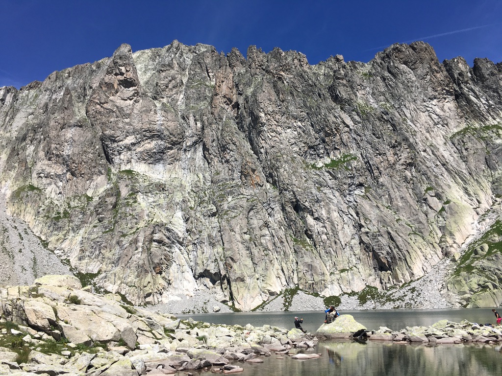
At the Pass, the view is spectacular on all sides. You get to contemplate the whole main Lagorai range in all its glory. Right in front of you, the now looming Cima d’Asta with its deep lake stupendously nestled right at the foot of the tall, 500-meter tall granite wall, and then, not too far from the lake river, the plateau where the Rifugio resides. I had my lunch while contemplating the views and pondering what to do next. From a distance, the Rifugio looked adorable, but I knew I would find chaos there. It was a beautiful mid-July Saturday, and Cima d’Asta is the most visited peak in the area. I was tired, even more than I had expected.
To complete the Alta Via, I only needed to reach the bottom of the valley and return to my motorcycle. Still, my super-secret goal was to climb the Cima d’Asta, which would have required another 500 meters of elevation gain. There I would sleep at the bivouac on the wall. However, all those crowds at the Rifugio and around the lake changed my mind. At the summit, I would have found dozens of people, and, more importantly, since the bivouac had only two beds, it was very likely to find fully occupied. At that point, I would have had to descend back to the lake and camp near the hut, something I wanted to avoid on a Saturday night. So, after a bit of wavering, I opted for the descent.
As always in Lagorai, the return to the bottom was not trivial, not at all. It was over a thousand meters drop on a steep and challenging trail down to the forest road that only covers the last couple of kilometers to Malga Sorgazza. I must also admit that during the descent, I was overtaken by several young people descending nimbly and quickly, an unmistakable sign that times have changed for me.
The motorcycle ride back was a three-and-a-half-hour non-stop ride home. I was in an almost catatonic state for the first hour or so. Then, I slowly recovered so much that I did not even feel the need to stop. With the mission accomplished, I only wanted to get home as soon as possible, which doesn’t mean I ran fast on the road; quite the contrary, given my tiredness. I learned that steady progress takes me home safely, pleasantly and often sooner than any other option.